Geographical Information Systems (GIS), like any specialized field, has a wealth of jargon and unique concepts. When represented in software, these concepts can sometimes be skewed or expanded from their original forms. We give a thorough definition of many of the core concepts here, while referencing the Geotrellis objects and source files backing them.
This document aims to be informative to new and experienced GIS users alike. If GIS is brand, brand new to you, this document is a useful high level overview.
Raster Data
“Yes raster is faster, but raster is vaster and vector just SEEMS more corrector.” — C. Dana Tomlin
Raster vs Tile
The entire purpose of geotrellis.raster is to provide primitive datatypes
which implement, modify, and utilize rasters. In GeoTrellis, a raster is
just a tile with an associated extent (read about extents below). A tile is
just a two-dimensional, collection of evenly spaced data. Tiles are a lot
like certain sequences of sequences (this array of arrays is like a 3x3
tile):
val myFirstTile = [[1,1,1],[1,2,2],[1,2,3]]
/** It probably looks more like your mental model if we stack them up:
  * [[1,1,1],
  *  [1,2,2],
  *  [1,2,3]]
  */
In the raster module of GeoTrellis, the base type of tile is just Tile.
All GeoTrellis compatible tiles will have inherited from that base class, so
if you find yourself wondering what a given type of tile's powers are,
that's a decent place to start your search. Here's an incomplete list of the
types of things on offer (Seriously, check out
the source code!
It will clarify the semantics of tiles in GeoTrellis.):
- Mapping transformations of arbitrary complexity over the constituent cells
- Carrying out operations (side-effects) for each cell
- Querying a specific tile value
- Rescaling, resampling, cropping
As we've already discussed, tiles are made up of squares which contain
values. We'll sometimes refer to these value-boxes as 'cells'. And, just
like cells in the body, though they are discrete units, they're most
interesting when looked at from a more holistic perspective - rasters encode
relations between values in a uniform space and it is usually these
relations which most interest us. The code found in the mapalgebra
submodule — discussed later in this document — is all about exploiting these
spatial relations.
Working with cell values
One of the first questions you'll ask yourself when working with GeoTrellis
is what kinds of representation best model the domain you're dealing with.
What types of value do you need your raster to hold? This question is the
province of GeoTrellis CellTypes. See below for a description of Cell
Types
Building Your Own Tiles
With a grasp of tiles and CellTypes, we've got all the conceptual tools
necessary to construct our own tiles. Now, since a tile is a combination of
a CellType with which its cells are encoded and their spatial arrangement,
we will have to somehow combine Tile (which encodes our expectations about
how cells sit with respect to one another) and the datatype of our choosing.
Luckily, GeoTrellis has done this for us. To keep its users sane, the wise
maintainers of GeoTrellis have organized geotrellis.raster such that fully
reified tiles sit at the bottom of an pretty simple inheritance chain. Let's
explore that inheritance so that you will know where to look when your
intuitions lead you astray:
From IntArrayTile.scala:
final case class IntArrayTile(array: Array[Int], cols: Int, rows: Int)
extends MutableArrayTile with IntBasedArrayTile
From DoubleArrayTile.scala:
final case class DoubleArrayTile(array: Array[Double], cols: Int, rows: Int)
extends MutableArrayTile with DoubleBasedArrayTile
Tile inheritance structure
It looks like there are two different chains of inheritance here
(IntBasedArrayTile and DoubleBasedArrayTile). Let's first look at what
they share:
MutableArrayTileadds some nifty methods for in-place manipulation of cells (GeoTrellis is about performance, so this minor affront to the gods of immutability can be forgiven). From MutableArrayTile.scala:
trait MutableArrayTile extends ArrayTile
- One level up is
ArrayTile. It's handy because it implements the behavior which largely allows us to treat our tiles like big, long arrays of (arrays of) data. They also have the traitSerializable, which is neat any time you can't completely conduct your business within the neatly defined space-time of the JVM processes which are running on a single machine (this is the point of GeoTrellis' Spark integration). From ArrayTile.scala:
trait ArrayTile extends Tile with Serializable
- At the top rung in our abstraction ladder we have
Tile. You might be surprised how much we can say about tile behavior from the base of its inheritance tree, so (at risk of sounding redundant) the source is worth spending some time on. From Tile.scala:
trait Tile
Cool. That wraps up one half of the inheritance. But how about that the
features they don't share? As it turns out, each reified tile's second piece
of inheritance merely implements methods for dealing with their constitutent
CellTypes. From IntBasedArrayTile.scala:
trait IntBasedArrayTile {
def apply(i:Int):Int
def update(i:Int, z:Int):Unit
def applyDouble(i:Int):Double = i2d(apply(i))
def updateDouble(i:Int, z:Double):Unit = update(i, d2i(z))
}
From DoubleBasedArrayTile.scala:
trait DoubleBasedArray {
def apply(i:Int):Int = d2i(applyDouble(i))
def update(i:Int, z:Int):Unit = updateDouble(i, i2d(z))
def applyDouble(i:Int):Double
def updateDouble(i:Int, z:Double):Unit
}
Mostly we've been looking to tiny snippets of source, but the two above are the entire files. All they do is:
- Tell the things that inherit from them that they'd better define methods for application and updating of values that look like their cells if they want the compiler to be happy.
- Tell the things that inherit from them exactly how to take values which
don't look like their cells (int-like things for
DoubleBasedArrayand double-like things forIntBasedArray) and turn them into types they find more palatable.
As it turns out, CellType is one of those things that we can mostly ignore
once we've settled on which one is proper for our domain. After all, it appears
as though there's very little difference between tiles that prefer int-like
things and tiles that prefer double-like things.
CAUTION: While it is true, in general, that operations are
CellTypeagnostic, bothgetandgetDoubleare methods implemented onTile. In effect, this means that you'll want to be careful when querying values. If you're working with int-likeCellTypes, probably useget. If you're working with float-likeCellTypes, usually you'll wantgetDouble.
Taking our tiles out for a spin
In the repl, you can try this out:
import geotrellis.raster._
import geotrellis.vector._
scala> IntArrayTile(Array(1,2,3),1,3)
res0: geotrellis.raster.IntArrayTile = IntArrayTile([S@338514ad,1,3)
scala> IntArrayTile(Array(1,2,3),3,1)
res1: geotrellis.raster.IntArrayTile = IntArrayTile([S@736a81de,3,1)
scala> IntArrayTile(Array(1,2,3,4,5,6,7,8,9),3,3)
res2: geotrellis.raster.IntArrayTile = IntArrayTile([I@5466441b,3,3)
Constructing a Raster
scala> Extent(0, 0, 1, 1)
res4: geotrellis.vector.Extent = Extent(0.0,0.0,1.0,1.0)
scala> Raster(res2, res4)
res5: geotrellis.raster.Raster = Raster(IntArrayTile([I@7b47ab7,1,3),Extent(0.0,0.0,1.0,1.0))
Here's a fun method for exploring your tiles:
scala> res0.asciiDraw()
res3: String =
" 1
2
3
"
scala> res2.asciiDraw()
res4: String =
" 1 2 3
4 5 6
7 8 9
"
That's probably enough to get started. geotrellis.raster is a pretty big
place, so you'll benefit from spending a few hours playing with the tools it
provides.
Vector Data
Vector Tiles
Invented by Mapbox, VectorTiles are a combination of the ideas of finite-sized tiles and vector geometries. Mapbox maintains the official implementation spec for VectorTile codecs. The specification is free and open source.
VectorTiles are advantageous over raster tiles in that:
- They are typically smaller to store
- They can be easily transformed (rotated, etc.) in real time
- They allow for continuous (as opposed to step-wise) zoom in Slippy Maps.
Raw VectorTile data is stored in the protobuf format. Any codec implementing
the spec must
decode and encode data according to this .proto
schema.
GeoTrellis provides the geotrellis-vectortile module, a high-performance
implementation of Version 2.1 of the VectorTile spec. It features:
- Decoding of Version 2 VectorTiles from Protobuf byte data into useful Geotrellis types.
- Lazy decoding of Geometries. Only parse what you need!
- Read/write VectorTile layers to/from any of our backends.
Ingests of raw vector data into VectorTile sets is still pending (as of 2016 October 28)
Small Example
import geotrellis.spark.SpatialKey
import geotrellis.spark.tiling.LayoutDefinition
import geotrellis.vector.Extent
import geotrellis.vectortile.VectorTile
import geotrellis.vectortile.protobuf._
val bytes: Array[Byte] = ... // from some `.mvt` file
val key: SpatialKey = ... // preknown
val layout: LayoutDefinition = ... // preknown
val tileExtent: Extent = layout.mapTransform(key)
/* Decode Protobuf bytes. */
val tile: VectorTile = ProtobufTile.fromBytes(bytes, tileExtent)
/* Encode a VectorTile back into bytes. */
val encodedBytes: Array[Byte] = tile match {
case t: ProtobufTile => t.toBytes
case _ => ??? // Handle other backends or throw errors.
}
See our VectorTile Scaladocs for detailed usage information.
Implementation Assumptions
This particular implementation of the VectorTile spec makes the following assumptions:
- Geometries are implicitly encoded in ''some'' Coordinate Reference system. That is, there is no such thing as a "projectionless" VectorTile. When decoding a VectorTile, we must provide a Geotrellis [[Extent]] that represents the Tile's area on a map. With this, the grid coordinates stored in the VectorTile's Geometry are shifted from their original [0,4096] range to actual world coordinates in the Extent's CRS.
- The
idfield in VectorTile Features doesn't matter. UNKNOWNgeometries are safe to ignore.- If a VectorTile
geometrylist marked asPOINThas only one pair of coordinates, it will be decoded as a GeotrellisPoint. If it has more than one pair, it will be decoded as aMultiPoint. Likewise for theLINESTRINGandPOLYGONtypes. A complaint has been made about the spec regarding this, and future versions may include a difference between single and multi geometries.
Tile Layers
Tile layers (Rasters or otherwise) are represented in GeoTrellis with the
type RDD[(K, V)] with Metadata[M]. This type is used extensively across
the code base, and its contents form the deepest compositional hierarchy we
have:
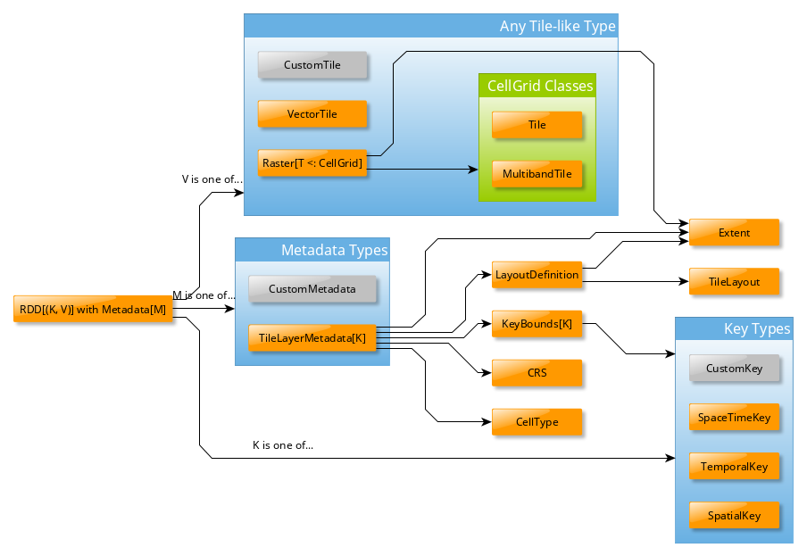
In this diagram:
CustomTile,CustomMetadata, andCustomKeydon't exist, they represent types that you could write yourself for your application.- The
Kseen in several places is the sameK. - The type
RDD[(K, V)] with Metadata[M]is a Scala Anonymous Type. In this case, it meansRDDfrom Apache Spark with extra methods injected from theMetadatatrait. This type is sometimes aliased in GeoTrellis asContextRDD. RDD[(K, V)]resembles a ScalaMap[K, V], and in fact has furtherMap-like methods injected by Spark when it takes this shape. See Spark's PairRDDFunctions Scaladocs for those methods. Note: UnlikeMap, theKs here are not guaranteed to be unique.
TileLayerRDD
A common specification of RDD[(K, V)] with Metadata[M] in GeoTrellis is as follows:
type TileLayerRDD[K] = RDD[(K, Tile)] with Metadata[TileLayerMetadata[K]]
This type represents a grid (or cube!) of Tiles on the earth, arranged
according to some K. Features of this grid are:
- Grid location
(0, 0)is the top-leftmostTile. - The
Tiles exist in some CRS. InTileLayerMetadata, this is kept track of with an actualCRSfield. - In applications,
Kis mostlySpatialKeyorSpaceTimeKey.
Tile Layer IO
Layer IO requires a Tile Layer Backend. Each backend
has an AttributeStore, a LayerReader, and a LayerWriter.
Example setup (with our File system backend):
import geotrellis.spark._
import geotrellis.spark.io._
import geotrellis.spark.io.file._
val catalogPath: String = ... /* Some location on your computer */
val store: AttributeStore = FileAttributeStore(catalogPath)
val reader = FileLayerReader(store)
val writer = FileLayerWriter(store)
Writing an entire layer:
/* Zoom level 13 */
val layerId = LayerId("myLayer", 13)
/* Produced from an ingest, etc. */
val rdd: TileLayerRDD[SpatialKey] = ...
/* Order your Tiles according to the Z-Curve Space Filling Curve */
val index: KeyIndex[SpatialKey] = ZCurveKeyIndexMethod.createIndex(rdd.metadata.bounds)
/* Returns `Unit` */
writer.write(layerId, rdd, index)
Reading an entire layer:
/* `.read` has many overloads, but this is the simplest */
val sameLayer: TileLayerRDD[SpatialKey] = reader.read(layerId)
Querying a layer (a "filtered" read):
/* Some area on the earth to constrain your query to */
val extent: Extent = ...
/* There are more types that can go into `where` */
val filteredLayer: TileLayerRDD[SpatialKey] =
reader.query(layerId).where(Intersects(extent)).result
Typeclasses
Typeclasses are a common feature of Functional Programming. As stated in Cell Types, typeclasses group data types by what they can do, as opposed to by what they are. If traditional OO inheritance arranges classes in a tree hierarchy, typeclasses arrange them in a graph.
Typeclasses are realized in Scala through a combination of traits and
implicit class wrappings. A typeclass constraint is visible in a
class/method signature like this:
class Foo[A: Order](a: A) { ... }
Meaning that Foo can accept any A, so long as it is "orderable". In reality,
this in syntactic sugar for the following:
class Foo[A](a: A)(implicit ev: Order[A]) { ... }
Here's a real-world example from GeoTrellis code:
protected def _write[
K: AvroRecordCodec: JsonFormat: ClassTag,
V: AvroRecordCodec: ClassTag,
M: JsonFormat: GetComponent[?, Bounds[K]]
](layerId: LayerId, rdd: RDD[(K, V)] with Metadata[M], keyIndex: KeyIndex[K]): Unit = { ... }
A few things to notice:
- Multiple constraints can be given to a single type variable:
K: Foo: Bar: Baz ?refers toM, helping the compiler with type inference. UnfortunatelyM: GetComponent[M, Bounds[K]]is not syntactically possible
Below is a description of the most-used typeclasses used in GeoTrellis. All are written by us, unless otherwise stated.
ClassTag
Built-in from scala.reflect. This allows classes to maintain some type
information at runtime, which in GeoTrellis is important for serialization.
You will never need to use this directly, but may have to annotate your
methods with it (the compiler will let you know).
JsonFormat
From the spray library. This constraint says that its type can be
converted to and from JSON, like this:
def toJsonAndBack[A: JsonFormat](a: A): A = {
val json: Value = a.toJson
json.convertTo[A]
}
AvroRecordCodec
Any type that can be serialized by Apache Avro.
While references to AvroRecordCodec appear frequently through GeoTrellis
code, you will never need to use its methods. They are used internally by
our Tile Layer Backends and Spark.
Boundable
Always used on K, Boundable means your key type has a finite bound.
trait Boundable[K] extends Serializable {
def minBound(p1: K, p2: K): K
def maxBound(p1: K, p2: K): K
... // etc
}
Component
Component is a bare-bones Lens. A Lens is a pair of functions that
allow one to generically get and set values in a data structure. They are
particularly useful for nested data structures. Component looks like this:
trait Component[T, C] extends GetComponent[T, C] with SetComponent[T, C]
Which reads as "if I have a T, I can read a C out of it" and "if I have
a T, I can write some C back into it". The lenses we provide are as follows:
SpatialComponent[T]- read aSpatialKeyout of a someT(usuallySpatialKeyorSpaceTimeKey)TemporalComponent[T]- read aTemporalKeyof someT(usuallySpaceTimeKey)
Functor
A Functor is anything that maintains its shape and semantics when map'd
over. Things like List, Map, Option and even Future are Functors.
Set and binary trees are not, since map could change the size of a Set
and the semantics of BTree.
Vanilla Scala does not have a Functor typeclass, but implements its
functionality anyway. Libraries like Cats and
ScalaZ provide a proper Functor, but
their definitions don't allow further constraints on your inner type. We
have:
trait Functor[F[_], A] extends MethodExtensions[F[A]]{
/** Lift `f` into `F` and apply to `F[A]`. */
def map[B](f: A => B): F[B]
}
which allows us to do:
def foo[M[_], K: SpatialComponent: λ[α => M[α] => Functor[M, α]]](mk: M[K]) { ... }
which says "M can be mapped into, and the K you find is guaranteed to
have a SpatialComponent as well".
Keys and Key Indexes
Tiles
Cell
Types
What is a Cell Type?
- A
CellTypeis a data type plus a policy for handling cell values that may contain no data. - By 'data type' we shall mean the underlying numerical representation
of a
Tile's cells. NoData, for performance reasons, is not represented as a value outside the range of the underlying data type (as, e.g.,None) - if each cell in some tile is aByte, theNoDatavalue of that tile will exist within the range [Byte.MinValue(-128),Byte.MaxValue(127)].- If attempting to convert between
CellTypes, see this note onCellTypeconversions.
| No NoData | Constant NoData | User Defined NoData | |
|---|---|---|---|
| BitCells | BitCellType |
N/A | N/A |
| ByteCells | ByteCellType |
ByteConstantNoDataCellType |
ByteUserDefinedNoDataCellType |
| UbyteCells | UByteCellType |
UByteConstantNoDataCellType |
UByteUserDefinedNoDataCellType |
| ShortCells | ShortCellType |
ShortConstantNoDataCellType |
ShortUserDefinedNoDataCellType |
| UShortCells | UShortCellType |
UShortConstantNoDataCellType |
UShortUserDefinedNoDataCellType |
| IntCells | IntCellType |
IntConstantNoDataCellType |
IntUserDefinedNoDataCellType |
| FloatCells | FloatCellType |
FloatConstantNoDataCellType |
FloatUserDefinedNoDataCellType |
| DoubleCells | DoubleCellType |
DoubleConstantNoDataCellType |
DoubleUserDefinedNoDataCellType |
The above table lists CellType DataTypes in the leftmost column
and NoData policies along the top row.
A couple of points are worth
making here:
- Bits are incapable of representing on, off, and some
NoDatavalue. As a consequence, there is no such thing as a Bit-backed tile which recognizesNoData. - While the types in the 'No NoData' and 'Constant NoData' are simply
singleton objects that are passed around alongside tiles, the greater
configurability of 'User Defined NoData'
CellTypes means that they require a constructor specifying the value which will count asNoData.
Let's look to how this information can be used:
/** Here's an array we'll use to construct tiles */
val myData = Array(42, 1, 2, 3)

/** The GeoTrellis-default integer CellType
 *   Note that it represents `NoData` values with the smallest signed
 *   integer possible with 32 bits (Int.MinValue or -2147483648).
 */
val defaultCT = IntConstantNoDataCellType
val normalTile = IntArrayTile(myData, 2, 2, defaultCT)

/** A custom, 'user defined' NoData CellType for comparison; we will
 *   treat 42 as NoData for this one rather than Int.MinValue
 */
val customCellType = IntUserDefinedNoDataValue(42)
val customTile = IntArrayTile(myData, 2, 2, customCellType)

/** We should expect that the first (default celltype) tile has the value 42 at (0, 0)
 *   This is because 42 is just a regular value (as opposed to NoData)
 *   which means that the first value will be delivered without surprise
 */
assert(normalTile.get(0, 0) == 42)
assert(normalTile.getDouble(0, 0) == 42.0)

/** Here, the result is less obvious. Under the hood, GeoTrellis is
 *   inspecting the value to be returned at (0, 0) to see if it matches our
 *   `NoData` policy and, if it matches (it does, we defined NoData as
 *   42 above), return Int.MinValue (no matter your underlying type, `get`
 *   on a tile will return an `Int` and `getDouble` will return a `Double`).
 *
 *   The use of Int.MinValue and Double.NaN is a result of those being the
 *   GeoTrellis-blessed values for NoData - below, you'll find a chart that
 *   lists all such values in the rightmost column
 */
assert(customTile.get(0, 0) == Int.MinValue)
assert(customTile.getDouble(0, 0) == Double.NaN)
A point which is perhaps not intuitive is that get will always
return an Int and getDouble will always return a Double.
Representing NoData demands, therefore, that we map other celltypes'
NoData values to the native, default Int and Double NoData
values. NoData will be represented as Int.MinValue or Double.Nan.
Why you should care
In most programming contexts, it isn't all that useful to think carefully about the number of bits necessary to represent the data passed around by a program. A program tasked with keeping track of all the birthdays in an office or all the accidents on the New Jersey turnpike simply doesn't benefit from carefully considering whether the allocation of those extra few bits is really worth it. The costs for any lack of efficiency are more than offset by the savings in development time and effort. This insight - that computers have become fast enough for us to be forgiven for many of our programming sins - is, by now, truism.
An exception to this freedom from thinking too hard about implementation details is any software that tries, in earnest, to provide the tools for reading, writing, and working with large arrays of data. Rasters certainly fit the bill. Even relatively modest rasters can be made up of millions of underlying cells. Additionally, the semantics of a raster imply that each of these cells shares an underlying data type. These points - that rasters are made up of a great many cells and that they all share a backing data type - jointly suggest that a decision regarding the underlying data type could have profound consequences. More on these consequences below.
Compliance with the GeoTIFF standard is another reason that management of cell types is important for GeoTrellis. The most common format for persisting a raster is the GeoTIFF. A GeoTIFF is simply an array of data along with some useful tags (hence the 'tagged' of 'tagged image file format'). One of these tags specifies the size of each cell and how those bytes should be interpreted (i.e. whether the data for a byte includes its sign - positive or negative - or whether it counts up from 0 - and is therefore said to be 'unsigned').
In addition to keeping track of the memory used by each cell in a Tile,
the cell type is where decisions about which values count as data (and
which, if any, are treated as NoData). A value recognized as NoData
will be ignored while mapping over tiles, carrying out focal operations
on them, interpolating for values in their region, and just about all of
the operations provided by GeoTrellis for working with Tiles.
Cell Type Performance
There are at least two major reasons for giving some thought to the types of data you'll be working with in a raster: persistence and performance.
Persistence is simple enough: smaller datatypes end up taking less space
on disk. If you're going to represent a region with only true/false
values on a raster whose values are Doubles, 63/64 bits will be wasted.
Naively, this means somewhere around 63 times less data than if the most
compact form possible had been chosen (the use of BitCells would
be maximally efficient for representing the bivalent nature of boolean
values). See the chart below for a sense of the relative sizes of these
cell types.
The performance impacts of cell type selection matter in both a local and a distributed (spark) context. Locally, the memory footprint will mean that as larger cell types are used, smaller amounts of data can be held in memory and worked on at a given time and that more CPU cache misses are to be expected. This latter point - that CPU cache misses will increase - means that more time spent shuffling data from the memory to the processor (which is often a performance bottleneck). When running programs that leverage spark for compute distribution, larger data types mean more data to serialize and more data send over the (very slow, relatively speaking) network.
In the chart below, DataTypes are listed in the leftmost column and
important characteristics for deciding between them can be found to the
right. As you can see, the difference in size can be quite stark depending on
the cell type that a tile is backed by. That extra space is the price
paid for representing a larger range of values. Note that bit cells
lack the sufficient representational resources to have a NoData value.
| Bits / Cell | 512x512 Raster (mb) | Range (inclusive) | GeoTrellis NoData Value | |
|---|---|---|---|---|
| BitCells | 1 | 0.032768 | [0, 1] | N/A |
| ByteCells | 8 | 0.262144 | [-128, 128] | -128 (Byte.MinValue) |
| UbyteCells | 8 | 0.262144 | [0, 255] | 0 |
| ShortCells | 16 | 0.524288 | [-32768, 32767] | -32768 (Short.MinValue) |
| UShortCells | 16 | 0.524288 | [0, 65535] | 0 |
| IntCells | 32 | 1.048576 | [-2147483648, 2147483647] | -2147483648 (Int.MinValue) |
| FloatCells | 32 | 1.048576 | [-3.40E38, 3.40E38] | Float.NaN |
| DoubleCells | 64 | 2.097152 | [-1.79E308, 1.79E308] | Double.NaN |
One final point is worth making in the context of CellType
performance: the Constant types are able to depend upon macros which
inline comparisons and conversions. This minor difference can certainly
be felt while iterating through millions and millions of cells. If possible, Constant
NoData values are to be preferred. For convenience' sake, we've
attempted to make the GeoTrellis-blessed NoData values as unobtrusive
as possible a priori.
The limits of expected return types (discussed in the previous section) is used by
macros to squeeze as much speed out of the JVM as possible. Check out
our macros docs
for more on our use of macros like isData and isNoData.
Projections
What is a projection?
In GIS, a projection is a mathematical transformation of Latitude/Longitude coordinates on a sphere onto some other flat plane. Such a plane is naturally useful for representing a map of the earth in 2D. A projection is defined by a Coordinate Reference System (CRS), which holds some extra information useful for reprojection. CRSs themselves have static definitions, have agreed-upon string representations, and are usually made public by standards bodies or companies. They can be looked up at SpatialReference.org.
A reprojection is the transformation of coorindates in one CRS to another.
To do so, coordinates are first converted to those of a sphere. Every CRS
knows how to convert between its coordinates and a sphere's, so a
transformation CRS.A -> CRS.B -> CRS.A is actually CRS.A -> Sphere ->
CRS.B -> Sphere -> CRS.A. Naturally some floating point error does
accumulate during this process.
Data structures: CRS, LatLng, WebMercator, ConusAlbers
Sources: geotrellis.proj4.{CRS, LatLng, WebMercator, ConusAlbers}
Within the context of Geotrellis, the main projection-related object is the
CRS trait. It stores related CRS objects from underlying libraries, and
also provides the means for defining custom reprojection methods, should the
need arise. It's companion object provides convenience functions for
creating CRSs. Geotrellis currently has three objects that implement the
CRS trait: LatLng, WebMercator, and ConusAlbers.
What can CRSs do?
They can be transformed back into their String representations:
self => toWKT, toProj4String
How are CRSs used throughout Geotrellis?
CRSs are stored in the *ProjecedExtent classes and are used chiefly
to define how reprojections should operate. Example:
val wm = Line(...)  // A `LineString` vector object in WebMercator.
val ll: Line = wm.reproject(WebMercator, LatLng)  // The Line reprojected into LatLng.
Extents
Data structures: Extent, ProjectedExtent, TemporalProjectedExtent,
GridExtent, RasterExtent
Sources: geotrellis.vector.Extent,
geotrellis.vector.reproject.Reproject,
geotrellis.spark.TemporalProjectExtent,
geotrellis.raster.{ GridExtent, RasterExtent },
geotrellis.raster.reproject.ReprojectRasterExtent
What is an extent?
An Extent is a rectangular section of a 2D projection of the Earth. It is
represented by two coordinate pairs that are its "min" and "max" corners in
some Coorindate Reference System. "min" and "max" here are CRS
specific, as the location of the point (0,0) varies between different CRS.
An Extent can also be referred to as a Bounding Box.
Within the context of Geotrellis, the points within an Extent always
implicitely belong to some CRS, while a ProjectedExtent holds both the
original Extent and its current CRS. If you ever wish to reproject an
extent, you'd need the original CRS and hence a ProjectedExtent.
What can Extents do?
Extents can perform operations on themselves and other objects.
self => expansion, translation, reprojection
other: Extent => distance, intersection
other: Point => contains
What are the other *Extent types?
A GridExtent is any Extent which contains an extra internal grid. Grid
coordinates follow Graphics / Matrix conventions, where (0,0) is at the
top-left. The cells of this grid are usually larger than the individual
points of the underlying map.
A GridExtent specific to rasters, where the underlying map is some image
(possibly held in an Array[Byte]) is called a RasterExtent.
RasterExtents are used heavily in the raster subproject. Both GridExtent
and RasterExtent can be reprojected.
How are Extents used throughout Geotrellis?
Extents are held by LayoutDefinitions, which in turn are used heavily in
Raster reading, writing, and reprojection.
How does reprojection work?
Below is the rough call stack when projecting an Extent. It assumes you're
starting with a ProjectExtent so that the original CRS is available.
ProjectedExtent.reproject(CRS)
ReprojectExtent(Extent)  // implicit class wrapping
ReprojectExtent.reproject(CRS, CRS)
Reproject.apply(Extent, CRS, CRS)
Reproject.apply(Polygon, CRS, CRS)
Reproject.apply(Polygon, Transform(CRS, CRS))  // A transform is a function that translates a Point
                                               // via some inner `Transform` object, by default
                                               // a `BasicCoordinateTransform` from Proj4.
Polygon.apply(Reproject.apply(Line, Transform), Array[Line])  // Line is reprojected.
Polygon.envelope  // from `Geometry` trait
Geometry.jtsGeom.getEnvelopeInternal
Extent.jts2Extent(jts.geom.Envelope)  // implicitly. This is the final `Extent`.
So basically
Extent => ReprojectExtent => Polygon => Line => (projected) Line => Polygon => jts.geom.Envelope => Extent
Layout Definitions
Data structures: LayoutDefinition, TileLayout, CellSize
Sources: geotrellis.spark.tiling.LayoutDefinition
What is a Layout Definition?
A Layout Definition describes the location, dimensions of, and organization of a tiled area of a map. Conceptually, the tiled area forms a grid, and the Layout Definitions describes that grid's area and cell width/height.
Within the context of Geotrellis, the LayoutDefinition class extends
GridExtent, and exposes methods for querying the sizes of the grid and
grid cells. Those values are stored in the TileLayout (the grid
description) and CellSize classes respectively. LayoutDefinitions are
used heavily during the raster reprojection process.
In essence, a LayoutExtent is the minimum information required to
describe some tiled map area in Geotrellis.
How are Layout Definitions used throughout Geotrellis?
They are used heavily when reading, writing, and reprojecting Rasters.
Map Algebra
Map Algebra is a name given by Dr. Dana Tomlin in the 1980's to a way of manipulating and transforming raster data. There is a lot of literature out there, not least the book by the guy who "wrote the book" on map algebra, so we will only give a brief introduction here. GeoTrellis follows Dana's vision of map algebra operations, although there are many operations that fall outside of the realm of Map Algebra that it also supports.
Map Algebra operations fall into 3 general categories:
Local Operations

Local operations are ones that only take into account the information of on cell at a time. In the animation above, we can see that the blue and the yellow cell are combined, as they are corresponding cells in the two tiles. It wouldn't matter if the tiles were bigger or smaller - the only information necessary for that step in the local operation is the cell values that correspond to each other. A local operation happens for each cell value, so if the whole bottom tile was blue and the upper tile were yellow, then the resulting tile of the local operation would be green.
Focal Operations

Focal operations take into account a cell, and a neighborhood around that
cell. A neighborhood can be defined as a square of a specific size, or
include masks so that you can have things like circular or wedge-shaped
neighborhoods. In the above animation, the neighborhood is a 5x5 square
around the focal cell. The focal operation in the animation is a focalSum.
The focal value is 0, and all of the other cells in the focal neighborhood;
therefore the cell value of the result tile would be 8 at the cell
corresponding to the focal cell of the input tile. This focal operation
scans through each cell of the raster. You can imagine that along the
border, the focal neighborhood goes outside of the bounds of the tile; in
this case the neighborhood only considers the values that are covered by the
neighborhood. GeoTrellis also supports the idea of an analysis area, which
is the GridBounds that the focal operation carries over, in order to support
composing tiles with border tiles in order to support distributed focal
operation processing.
Zonal Operations
Zonal operations are ones that operate on two tiles: an input tile, and a
zone tile. The values of the zone tile determine what zone each of the
corresponding cells in the input tile belong to. For example, if you are
doing a zonalStatistics operation, and the zonal tile has a distribution
of zone 1, zone 2, and zone 3 values, we will get back the statistics such
as mean, median and mode for all cells in the input tile that correspond to
each of those zone values.
How to use Map Algebra operations
Map Algebra operations are defined as implicit methods on Tile or
Traversable[Tile], which are imported with import geotrellis.raster._.
import geotrellis.raster._

val tile1: Tile = ???
val tile2: Tile = ???

// If tile1 and tile2 are the same dimensions, we can combine
// them using local operations

tile1.localAdd(tile2)

// There are operators for some local operations.
// This is equivalent to the localAdd call above

tile1 + tile2

// There is a local operation called "reclassify" in literature,
// which transforms each value of the function.
// We actually have a map method defined on Tile,
// which serves this purpose.

tile1.map { z => z + 1 } // Map over integer values.

tile2.mapDouble { z => z + 1.1 } // Map over double values.

tile1.dualMap({ z => z + 1 })({ z => z + 1.1 }) // Call either the integer value or double version, depending on cellType.

// You can also combine values in a generic way with the combine funciton.
// This is another local operation that is actually defined on Tile directly.

tile1.combine(tile2) { (z1, z2) => z1 + z2 }
The following packages are where Map Algebra operations are defined in GeoTrellis:
geotrellis.raster.localdefines operations which act on a cell without regard to its spatial relations. Need to double every cell on a tile? This is the module you'll want to explore.geotrellis.raster.focaldefines operations which focus on two-dimensional windows (internally referred to as neighborhoods) of a raster's values to determine their outputs.geotrellis.raster.zonaldefines operations which apply over a zones as defined by corresponding cell values in the zones raster.
Conway's Game of Life
can be seen as a focal operation in that each cell's value depends on
neighboring cell values. Though focal operations will tend to look at a
local region of this or that cell, they should not be confused with the
operations which live in geotrellis.raster.local - those operations
describe transformations over tiles which, for any step of the calculation,
need only know the input value of the specific cell for which it is
calculating an output (e.g. incrementing each cell's value by 1).